There is a bike trail called the Tony Knowles Coastal Trail that goes in front of downtown, past the lagoon, mud flats and through Earthquake Park. Earthquake Park is dedicated to the people who lived and died during the 1964 earthquake that devastated the city. The park stands on what used to be the downtown area prior to the earthquake and was moved to its current location when it was rebuilt.
We started our ride at Earthquake Park and rode to the Lagoon and back which was about 10 miles with the return mostly uphill.
As we pulled out of Earthquake Park we came across our first citing of urban moose. Two of the 1000 that live within the city limits.
We started our ride at Earthquake Park and rode to the Lagoon and back which was about 10 miles with the return mostly uphill.
As we pulled out of Earthquake Park we came across our first citing of urban moose. Two of the 1000 that live within the city limits.

As we continued our drive out of Anchorage we drove through the Anchorage Coastal Wildlife Refuge which stretches for 16 miles along the Anchorage Coastline. It’s most popular spot is Potter Marsh which is home to Artic Terns, Canada Geese, Grebes, Bald Eagles, Owls, Gulls and Ducks. It was cold and rainy and all we saw were a few ducks so we didn’t stay long.

We continued along the Seward Highway which ran right along the coast of Turnagain Arm which eventually runs into Cook Inlet.

 Our next stop was going to be Portage Glacier which was about 50 miles down the highway. However we could not help but notice how the terrain had changed. It was still mountainous but the vegetation had become much greener and thicker.

 Our next stop was going to be Portage Glacier which was about 50 miles down the highway. However we could not help but notice how the terrain had changed. It was still mountainous but the vegetation had become much greener and thicker.


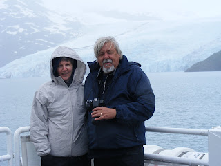
When we got to Portage it was raining and cold and we were not sure if we wanted to take the boat tour. We decided in the affirmative and as the last boat left at 4:30 we quickly changed clothes and donned wet weather gear.

The glacier is in Chugach National Forest and has been receding quickly over the last few years. Portage Lake was created when the glaciers in the immediate area receded. It is only 100 years old. The glacier is 4 ½ miles long and ½ mile wide at the point where it touches the lake. There is 400 feet of the glacier that is under water and the tour boat has to be careful of what they call shooters. These are large chunks of ice that break off under water and shoot to the top.
You can see some of the chunks floating in the water and piled up on shore at the other end of the lake.
An interesting fact is that there are 10,000 glaciers in the Chugach National Forest and 100,000 glaciers in Alaska. Mind boggling.
You can see some of the chunks floating in the water and piled up on shore at the other end of the lake.
An interesting fact is that there are 10,000 glaciers in the Chugach National Forest and 100,000 glaciers in Alaska. Mind boggling.


 We left Portage and headed down the highway and entered into the Kenai Peninsula.
Our first stop in the Kenai was to detour off the Seward Highway and head into Hope, Alaska and hoped we would find a spot to stop for the night.

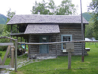
Hope is an old gold mining town that is on the other side of Turnagain Arm from Anchorage and in fact many people from Anchorage retire to Hope. The town has maintained and still use a lot of the buildings that were built in the late 1800’s and early 1900’s when the gold rush was on.


As it turned out Hope was not as we hoped. We could not find a campsite so we headed back towards the Seward Highway. Our plan was to follow the Seward Highway to the Sterling Highway and head towards Sterling. We then cut off at Skilak Lake Road which had a number of Campsites on it. The road was gravel and quite rough in places and we were hoping to see some wildlife. What we did find out is that on the weekends all the campsites fill up early. After checking a couple we did what all good boondockers do. We pulled off into a cut out and went to sleep.

ANIMAL COUNT FOR THE DAY
Moose 3
Saturday June, 13, 2009
Oh my goodness, its 5:30AM and we are up. We got up early as we were told by someone that we could see a lot of wildlife on this road. They lied. All we saw was tons of wascally wabbits. Be veery veery careful.
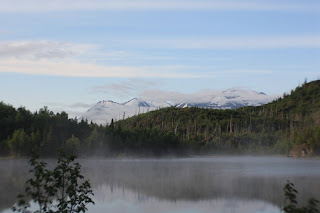
No wildlife but the early morning scenery was spectacular. The mist on the lakes and mountains was spell binding. It was so mesmorizing that I almost forgot to eat my peanut butter and banana sandwich. Almost.


 We finished the drive on the Skilak Lake Road and got back on the Sterling Highway and headed west towards Soldotna. We stopped for gas, groceries and of course a Star Bucks and then left the Sterling Highway and took the Kenai Spur Highway north. We followed this highway through Kenai, Nikiski and into the Captain Cook Recreation Area where the road ended.
We turned around and headed back south on the Kenai Spur Highway. We stopped at Kenai as this is where the Kenai River flows into Cook Inlet and is a good spot to see Beluga Whales.

Well, maybe for most people. All we saw was two seals playing in the surf.
We then decided to follow the Kalifornsky Beach Road along the coast to Kasilof where we joined up with the Sterling Highway once again.
The traffic along the Sterling Highway was a lot heavier that anything we saw north of Anchorage and the smaller towns were closer together and a little heavier populated. Each of these small towns has something unique to offer, however we decided to head straight to Homer. We will stop and visit them on the way back. The Sterling Highway is the only road in and out of Homer therefore we have to reverse our path when we decide to leave for Seward.
On the way to Homer we passed Redoubt Mountain but could not see it for the clouds or ash, not sure which. It is an active Volcano that spread heavy ash over Homer as recently as April 4 of this year.
We did get a picture of Mount Augustine which makes up Augustine Island. This mountain has not had a eruption in the last four years but is still considered active.

We arrived in Homer and cruised around before setting up at the Ocean View RV park, I am sitting here writing this and looking out at the Cook Inlet. Life is good.
 ANIMAL COUNT OF THE DAY
Seals 2
Moose 1
.jpg)

3 comments:
How is the Temp
your trip looks amazing
I was going to wait until I caught up to comment but I wanted to mention that the shot of the urban moose is fantastic... What a pose!
Post a Comment